This post comes to us from Oonagh Jordan, a VISTA Fellow with the New York City Mayor’s Office of Opportunity. Oonagh is leading the project management of this initiative.
In New York City, community-based organizations that deliver programming at neighborhood sites play a crucial role in administering City-funded programs and services. There is, however, currently no central listing of all the city-funded service site locations across the five boroughs where this critical work occurs. If there were a list of this kind, agencies, policymakers, and advocates could better understand how resources are distributed throughout the City and address any gaps in service.
The Social Service Site Location Data project aims to support efficient interagency coordination, collaboration, and decision-making by making this information accessible. The project advances the City’s commitment to making it easier to discover what social services exist and where they are delivered, as outlined in One New York: The Plan for a Strong and Just City (One NYC), NYC’s long-term strategic plan. The project also supports the City’s commitment to transparency by publishing information on contracted City investments through Open Data, the City’s public data portal.*
This project is being led by the Mayor’s Office for Economic Opportunity (NYC Opportunity), which uses evidence and innovation to reduce poverty and increase equity. The Social Service Site Location Data project fits into the office’s work to advance equity by showing how social services and City investments are distributed throughout New York City.
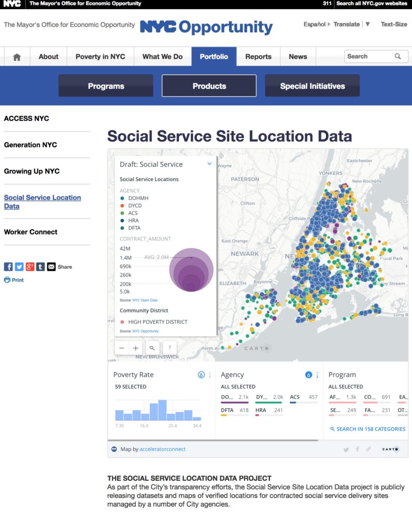
The Social Service Site Location Data project released the first public data set, compiled with contract data from key city agencies, in March 2018. This release included geocoded social service site delivery location data from the following New York City government agencies:
- Department of Health and Mental Hygiene (DOHMH)
- Department of Social Services (DSS)
- Department for the Aging (DFTA)
- Department of Youth and Community Development (DYCD)
- Data for three programs operated by the Administration for Children’s Services (ACS)
The locations of service sites for each agency’s social service programming are accessible on Open Data. (The Open Data listing for this project will be updated with data from additional agencies not included in the first release.)
To create this dataset, information was compiled from three sources:
- HHS Accelerator: The City’s contract procurement and management tool for most social service-related contracts
- Checkbook NYC: A tool created by the NYC Comptroller’s Office for tracking government spending
- City Agencies: Agencies and Offices added contracts that were not listed in Accelerator and Checkbook, and added or changed site addresses to reflect active service locations

After some research, NYC Opportunity decided to use the Human Services Data Specification, with some modifications, to organize the data. An advantage of using this existing open-source model is that it is already well-documented and easily ingestible by other applications or systems.
The current process for collecting, verifying, approving, and compiling this data is highly labor-intensive, so NYC Opportunity is looking for ways to create a more efficient, streamlined process for maintaining and publishing accurate site location data through NYC’s Open Data portal.
NYC Opportunity encourages anyone interested in resource distribution to explore and use the data. The office has created a map of the contracted social services in New York City using the Open Data submission, and looks forward to seeing how others use the data. To view the map and read more about the project, please visit the Social Service Site Location Data Project’s product page on the NYC Opportunity website.
The next release will be added to the project’s page on Open Data. To contact NYC Opportunity, please email [email protected].
*NB: As some City programming works with vulnerable populations, the locations of those service sites are sensitive information. Agencies had the opportunity to flag any of those programs, and request that the addresses for those sites not be published. In those cases, we were able to use a catchment area to capture the larger area in which services are delivered, such as a Community District or Neighborhood Tabulation Area.


Leave a Reply